Municipal Plan Review

Share Municipal Plan Review on Facebook Share Municipal Plan Review on X (formerly Twitter) Share Municipal Plan Review on Linkedin Email Municipal Plan Review link

We’re reviewing our Municipal Plan and Zoning By-Law!

Moncton is growing and evolving. Let’s create a new Municipal Plan and Zoning By-Law that supports a future as bright and dynamic as our city.

The City of Moncton’s current Municipal Plan and Zoning By-Law were adopted in 2014. Council is required to periodically review and update the Municipal Plan to ensure its objectives and policies remain current and relevant and to meet the requirements of the Community Planning Act and other provincial policies and regulations. The Zoning By-Law must be updated to conform to the new Municipal Plan.

Once the review is complete, the City of Moncton will have an updated Municipal Plan and Zoning By-Law that is forward-looking and that will help ensure future growth and development aligns with the community’s goals and priorities.


THE POLICY DIRECTION REPORT AND BIG MOVES

Following several rounds of public engagement, the City has identified three Big Moves to guide the ongoing review of the City's Municipal Plan:

  • Establishing Transit Corridors,
  • Designing for People, and
  • Celebrating Downtown.

The City is also reviewing the intent of land use designations and best practices to ensure these planning tools serve the City's residents well.


How will these Big Moves be implemented?

Below is an overview of proposed key changes to support the Big Moves and Policy Directions:


Corridors

Driven by the first Big Move, the current Mixed Use Centres and Corridors Designation was split into three:

  • Mixed-use Transit Corridors Designation,
  • Neighbourhood Corridor Designation, and
  • Growth Node Designation.

The proposed corridor designations will feature a reduction of auto-dependent uses and an increase in density, building heights, and mix of uses but with a goal to blending future development with the adjacent existing neighbourhood.

New Mixed-Use Transit Corridors Designation applied along Mountain Blvd, West Main St, St. George between Milner and Vaughan Harvey, Millennium Blvd, Killam, North of the Roundabout, Morton/Elmwood.

New Neighbourhood Corridor Designation applied along Ryan, Purdy, Connaught/MacBeath, McLaughlin, Mill, Shediac between Maclaren and Weston.

New Growth Node Designation applied around Vaughan Harvey + Millennium, Wheeler + Mapleton, and Harrisville + Babineau.


Designing for People

The development standards in downtown, as well as several other areas of the city, are being reviewed to ensure they are the best for the residents and businesses. Proposed new standards will focus on pedestrian-friendly design and a high-quality public realm.


Downtown

To celebrate Downtown, the Downtown Designation area was expanded north up to John St and Botsford St/Wheeler Blvd. A new downtown neighbourhood zone is proposed that would allow more flexibility to land uses in the area while maintaining a low-rise built form.


NEW: GENERALIZED FUTURE LAND USE MAP

Moncton’s Generalized Future Land Use Map is a key component of the City’s long-term planning document, acting as the visual guide for its Municipal Plan.

The map outlines the community's vision for how and where land should develop over the next 25+ years, visually locating where residential, commercial, recreational, institutional, and industrial developments are encouraged.


Link to Generalized Future Land Use Public Engagement Map


How to Use the Generalized Future Land Use Public Engagement Map

Pour accéder à la version française de la carte, veuillez cliquer sur « Français » dans le coin supérieur droit de la carte.
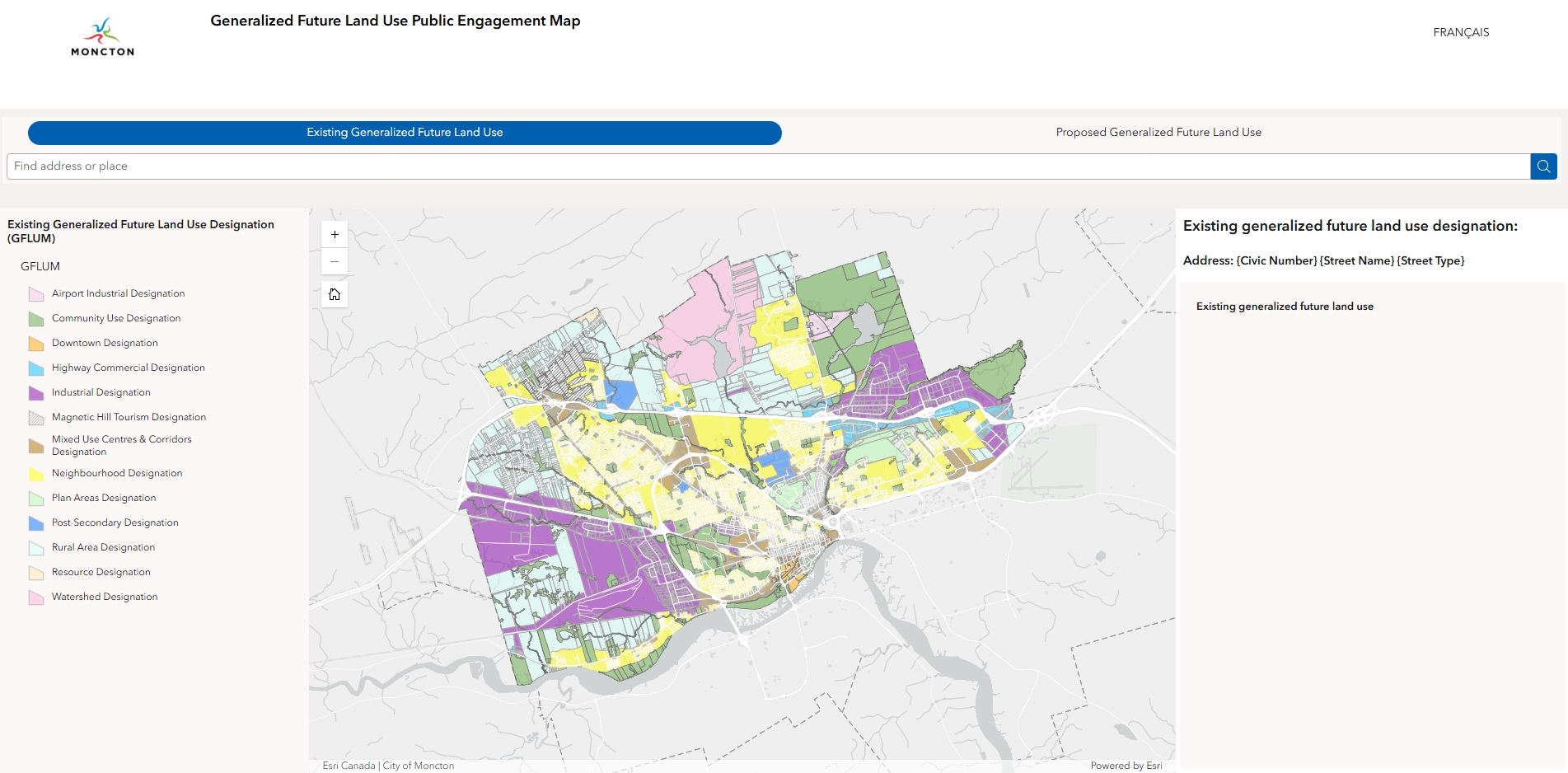

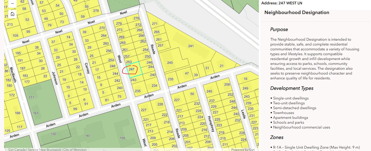
To find the designation information for a specific address, enter the address you are searching for in the “find address or place” search box and hit ‘enter’ or use your mouse and cursor on map to find the address.
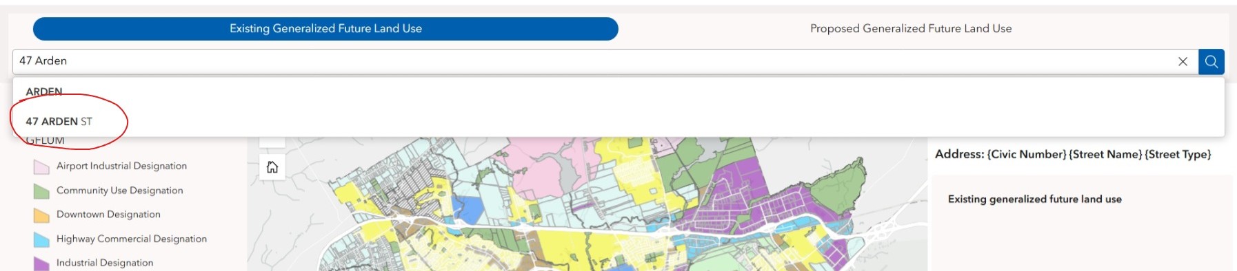

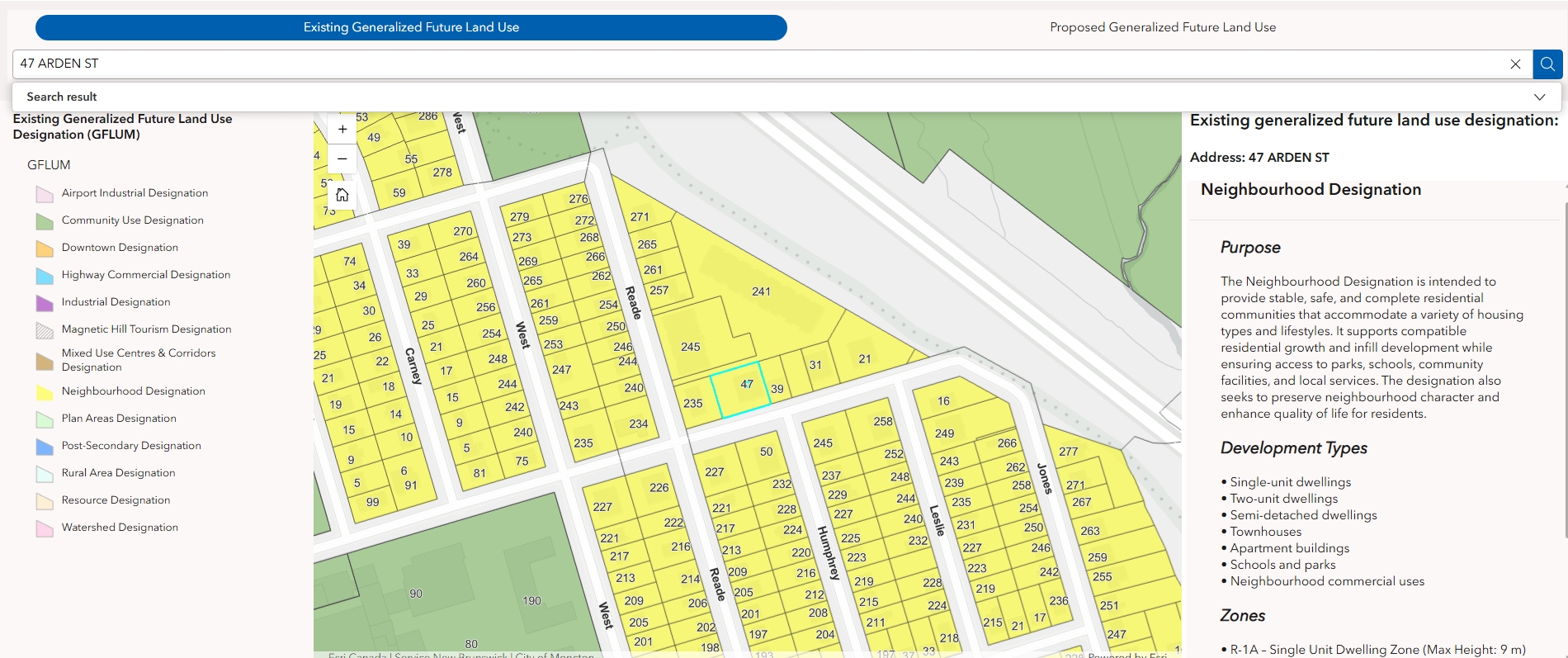
The map will zoom to the selected address and display the existing generalized future land use designation information on the right side.

Click on ‘Proposed Generalized Future Land Use’ at the top to change the map to the proposed generalized future land use designation information.


The map will now show the proposed information for the same property.
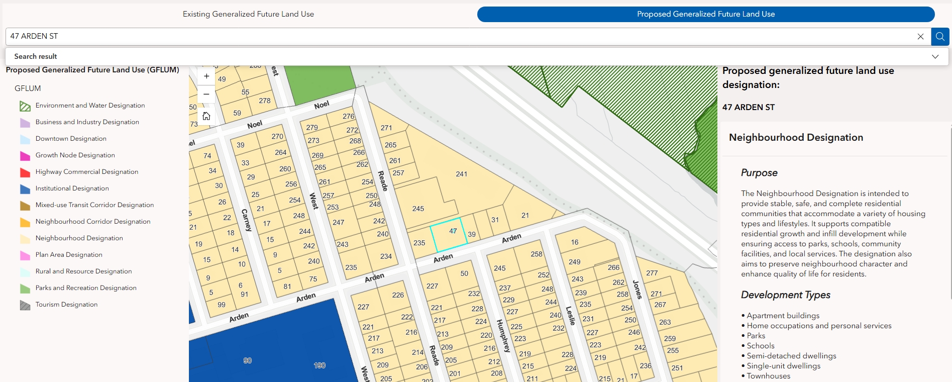

Alternatively, you can click on the civic number on the map to bring up the same information.

JOIN THE CONVERSATION, ON YOUR TERMS

We want to hear from you! We understand your time is valuable, so we’ve planned multiple ways for you to get involved.

Several rounds of engagement will be held to:

  • hear and learn from you
  • share key findings and updates
  • present and gather feedback on emerging ideas

Notifications for these engagement opportunities will be distributed once the dates have been planned. Details for each engagement opportunity will be on this page.

The tools, documents, and questions will change as the project progresses and as we learn more about the community's needs and interests, so check in often and share your thoughts!

HOW YOU CAN PARTICIPATE

Respond to the Quick Poll and Forum questions to share your thoughts about Moncton's current Vision Statement and Big Moves!

Submit any questions, comments, and ideas relating to the Municipal Plan Review in the Questions tab, and the team will respond, either publicly or privately, depending on the nature of the question.

We’re reviewing our Municipal Plan and Zoning By-Law!

Moncton is growing and evolving. Let’s create a new Municipal Plan and Zoning By-Law that supports a future as bright and dynamic as our city.

The City of Moncton’s current Municipal Plan and Zoning By-Law were adopted in 2014. Council is required to periodically review and update the Municipal Plan to ensure its objectives and policies remain current and relevant and to meet the requirements of the Community Planning Act and other provincial policies and regulations. The Zoning By-Law must be updated to conform to the new Municipal Plan.

Once the review is complete, the City of Moncton will have an updated Municipal Plan and Zoning By-Law that is forward-looking and that will help ensure future growth and development aligns with the community’s goals and priorities.


THE POLICY DIRECTION REPORT AND BIG MOVES

Following several rounds of public engagement, the City has identified three Big Moves to guide the ongoing review of the City's Municipal Plan:

  • Establishing Transit Corridors,
  • Designing for People, and
  • Celebrating Downtown.

The City is also reviewing the intent of land use designations and best practices to ensure these planning tools serve the City's residents well.


How will these Big Moves be implemented?

Below is an overview of proposed key changes to support the Big Moves and Policy Directions:


Corridors

Driven by the first Big Move, the current Mixed Use Centres and Corridors Designation was split into three:

  • Mixed-use Transit Corridors Designation,
  • Neighbourhood Corridor Designation, and
  • Growth Node Designation.

The proposed corridor designations will feature a reduction of auto-dependent uses and an increase in density, building heights, and mix of uses but with a goal to blending future development with the adjacent existing neighbourhood.

New Mixed-Use Transit Corridors Designation applied along Mountain Blvd, West Main St, St. George between Milner and Vaughan Harvey, Millennium Blvd, Killam, North of the Roundabout, Morton/Elmwood.

New Neighbourhood Corridor Designation applied along Ryan, Purdy, Connaught/MacBeath, McLaughlin, Mill, Shediac between Maclaren and Weston.

New Growth Node Designation applied around Vaughan Harvey + Millennium, Wheeler + Mapleton, and Harrisville + Babineau.


Designing for People

The development standards in downtown, as well as several other areas of the city, are being reviewed to ensure they are the best for the residents and businesses. Proposed new standards will focus on pedestrian-friendly design and a high-quality public realm.


Downtown

To celebrate Downtown, the Downtown Designation area was expanded north up to John St and Botsford St/Wheeler Blvd. A new downtown neighbourhood zone is proposed that would allow more flexibility to land uses in the area while maintaining a low-rise built form.


NEW: GENERALIZED FUTURE LAND USE MAP

Moncton’s Generalized Future Land Use Map is a key component of the City’s long-term planning document, acting as the visual guide for its Municipal Plan.

The map outlines the community's vision for how and where land should develop over the next 25+ years, visually locating where residential, commercial, recreational, institutional, and industrial developments are encouraged.


Link to Generalized Future Land Use Public Engagement Map


How to Use the Generalized Future Land Use Public Engagement Map

Pour accéder à la version française de la carte, veuillez cliquer sur « Français » dans le coin supérieur droit de la carte.


To find the designation information for a specific address, enter the address you are searching for in the “find address or place” search box and hit ‘enter’ or use your mouse and cursor on map to find the address.


The map will zoom to the selected address and display the existing generalized future land use designation information on the right side.


Click on ‘Proposed Generalized Future Land Use’ at the top to change the map to the proposed generalized future land use designation information.


The map will now show the proposed information for the same property.


Alternatively, you can click on the civic number on the map to bring up the same information.


JOIN THE CONVERSATION, ON YOUR TERMS

We want to hear from you! We understand your time is valuable, so we’ve planned multiple ways for you to get involved.

Several rounds of engagement will be held to:

  • hear and learn from you
  • share key findings and updates
  • present and gather feedback on emerging ideas

Notifications for these engagement opportunities will be distributed once the dates have been planned. Details for each engagement opportunity will be on this page.

The tools, documents, and questions will change as the project progresses and as we learn more about the community's needs and interests, so check in often and share your thoughts!

HOW YOU CAN PARTICIPATE

Respond to the Quick Poll and Forum questions to share your thoughts about Moncton's current Vision Statement and Big Moves!

Submit any questions, comments, and ideas relating to the Municipal Plan Review in the Questions tab, and the team will respond, either publicly or privately, depending on the nature of the question.

Questions

Questions or comments?

Submit any questions or comments relating to this topic, and the team will respond, either publicly or privately, depending on the nature of the question.
Email
loader image
Didn't receive confirmation?
Seems like you are already registered, please provide the password. Forgot your password? Create a new one now.
  • Share What are the City’s plan on having a dedicated cricket field in Moncton? The City has been studying this issue for at least a year - would you in addition, also share the results of this study and whether a concrete conclusion has been reached vis a vis a dedicated cricket field for Moncton. on Facebook Share What are the City’s plan on having a dedicated cricket field in Moncton? The City has been studying this issue for at least a year - would you in addition, also share the results of this study and whether a concrete conclusion has been reached vis a vis a dedicated cricket field for Moncton. on X (formerly Twitter) Share What are the City’s plan on having a dedicated cricket field in Moncton? The City has been studying this issue for at least a year - would you in addition, also share the results of this study and whether a concrete conclusion has been reached vis a vis a dedicated cricket field for Moncton. on Linkedin Email What are the City’s plan on having a dedicated cricket field in Moncton? The City has been studying this issue for at least a year - would you in addition, also share the results of this study and whether a concrete conclusion has been reached vis a vis a dedicated cricket field for Moncton. link

    What are the City’s plan on having a dedicated cricket field in Moncton? The City has been studying this issue for at least a year - would you in addition, also share the results of this study and whether a concrete conclusion has been reached vis a vis a dedicated cricket field for Moncton.

    Bambi Mandy asked 15 days ago
    Thank you for your question!
    The feasibility study for a Rugby, Cricket, and Ultimate Frisbee facility will be presented to Council this fall. At that point, we should have a better understanding of the next steps and how/ if the project will move forward.

  • Share Referring to the maps keys I see that areas now designated as, "Rural Area Designation" on the "Existing generalized future land use designation" map, change to, "Rural and Resource Designation" on the "Proposed generalized future land use designation" map. What are the plans that would change the designation to include the label, "Resource" for those areas? on Facebook Share Referring to the maps keys I see that areas now designated as, "Rural Area Designation" on the "Existing generalized future land use designation" map, change to, "Rural and Resource Designation" on the "Proposed generalized future land use designation" map. What are the plans that would change the designation to include the label, "Resource" for those areas? on X (formerly Twitter) Share Referring to the maps keys I see that areas now designated as, "Rural Area Designation" on the "Existing generalized future land use designation" map, change to, "Rural and Resource Designation" on the "Proposed generalized future land use designation" map. What are the plans that would change the designation to include the label, "Resource" for those areas? on Linkedin Email Referring to the maps keys I see that areas now designated as, "Rural Area Designation" on the "Existing generalized future land use designation" map, change to, "Rural and Resource Designation" on the "Proposed generalized future land use designation" map. What are the plans that would change the designation to include the label, "Resource" for those areas? link

    Referring to the maps keys I see that areas now designated as, "Rural Area Designation" on the "Existing generalized future land use designation" map, change to, "Rural and Resource Designation" on the "Proposed generalized future land use designation" map. What are the plans that would change the designation to include the label, "Resource" for those areas?

    Wanda asked 26 days ago
    Thank you for your question!
    The current resource designation applies to only the existing quarry on Gorge Road. The City is proposing to merge the existing resource designation with the existing rural designation so that all rural uses are in one designation. There is no plan to expand the resource use/quarry and no plans to allow additional resource uses.

    The change to the name of the designation acknowledges the proposed merger of the current resource designation and rural designation.

  • Share I have lived in Montreal for 4 years and used to bike to work everyday during spring/summer. I have never had any issues in doing so when I shared the street with cars or on the bike lanes. In the 3 weeks since I have moved to Dieppe (I work in Moncton), I have been yelled at to leave the street and almost hit by a car in one occasion (it seemed the driver wasn't expecting a biker). I was also advised to not let my bike parked on the street, or else it would be stolen (a problem that Montreal also faces, in downtown). I feel that Moncton has similarities with Montreal (no steep hills, a nice riverfront) and has great potential to be a more bike-friendly city and I believe that making more bike lanes (dedicated when possible, but shared with cars is also possible) would make drivers more sensible and attentive to sharing the path with bikers and would make commuting to work a more viable option to many people who are simply afraid of doing so today. I encourage your administration to see some of the initiatives in Montreal that could be easily implemented here. most of them really simple and cost-effective on Facebook Share I have lived in Montreal for 4 years and used to bike to work everyday during spring/summer. I have never had any issues in doing so when I shared the street with cars or on the bike lanes. In the 3 weeks since I have moved to Dieppe (I work in Moncton), I have been yelled at to leave the street and almost hit by a car in one occasion (it seemed the driver wasn't expecting a biker). I was also advised to not let my bike parked on the street, or else it would be stolen (a problem that Montreal also faces, in downtown). I feel that Moncton has similarities with Montreal (no steep hills, a nice riverfront) and has great potential to be a more bike-friendly city and I believe that making more bike lanes (dedicated when possible, but shared with cars is also possible) would make drivers more sensible and attentive to sharing the path with bikers and would make commuting to work a more viable option to many people who are simply afraid of doing so today. I encourage your administration to see some of the initiatives in Montreal that could be easily implemented here. most of them really simple and cost-effective on X (formerly Twitter) Share I have lived in Montreal for 4 years and used to bike to work everyday during spring/summer. I have never had any issues in doing so when I shared the street with cars or on the bike lanes. In the 3 weeks since I have moved to Dieppe (I work in Moncton), I have been yelled at to leave the street and almost hit by a car in one occasion (it seemed the driver wasn't expecting a biker). I was also advised to not let my bike parked on the street, or else it would be stolen (a problem that Montreal also faces, in downtown). I feel that Moncton has similarities with Montreal (no steep hills, a nice riverfront) and has great potential to be a more bike-friendly city and I believe that making more bike lanes (dedicated when possible, but shared with cars is also possible) would make drivers more sensible and attentive to sharing the path with bikers and would make commuting to work a more viable option to many people who are simply afraid of doing so today. I encourage your administration to see some of the initiatives in Montreal that could be easily implemented here. most of them really simple and cost-effective on Linkedin Email I have lived in Montreal for 4 years and used to bike to work everyday during spring/summer. I have never had any issues in doing so when I shared the street with cars or on the bike lanes. In the 3 weeks since I have moved to Dieppe (I work in Moncton), I have been yelled at to leave the street and almost hit by a car in one occasion (it seemed the driver wasn't expecting a biker). I was also advised to not let my bike parked on the street, or else it would be stolen (a problem that Montreal also faces, in downtown). I feel that Moncton has similarities with Montreal (no steep hills, a nice riverfront) and has great potential to be a more bike-friendly city and I believe that making more bike lanes (dedicated when possible, but shared with cars is also possible) would make drivers more sensible and attentive to sharing the path with bikers and would make commuting to work a more viable option to many people who are simply afraid of doing so today. I encourage your administration to see some of the initiatives in Montreal that could be easily implemented here. most of them really simple and cost-effective link

    I have lived in Montreal for 4 years and used to bike to work everyday during spring/summer. I have never had any issues in doing so when I shared the street with cars or on the bike lanes. In the 3 weeks since I have moved to Dieppe (I work in Moncton), I have been yelled at to leave the street and almost hit by a car in one occasion (it seemed the driver wasn't expecting a biker). I was also advised to not let my bike parked on the street, or else it would be stolen (a problem that Montreal also faces, in downtown). I feel that Moncton has similarities with Montreal (no steep hills, a nice riverfront) and has great potential to be a more bike-friendly city and I believe that making more bike lanes (dedicated when possible, but shared with cars is also possible) would make drivers more sensible and attentive to sharing the path with bikers and would make commuting to work a more viable option to many people who are simply afraid of doing so today. I encourage your administration to see some of the initiatives in Montreal that could be easily implemented here. most of them really simple and cost-effective

    Daniel asked 25 days ago

    Thank you for your feedback about becoming a more bike-friendly city. We have added it to our collection of feedback in this engagement process!

  • Share Can someone tell me why we are leading truck from our neighborhood province I have notice several city vehicles with Nova Scotia plate explain why on Facebook Share Can someone tell me why we are leading truck from our neighborhood province I have notice several city vehicles with Nova Scotia plate explain why on X (formerly Twitter) Share Can someone tell me why we are leading truck from our neighborhood province I have notice several city vehicles with Nova Scotia plate explain why on Linkedin Email Can someone tell me why we are leading truck from our neighborhood province I have notice several city vehicles with Nova Scotia plate explain why link

    Can someone tell me why we are leading truck from our neighborhood province I have notice several city vehicles with Nova Scotia plate explain why

    Bunnies asked 26 days ago

    Thank you for your question!

    The City always rents locally from Moncton. When there is insufficient inventory, vehicles are sourced from neighbouring provinces. 

  • Share I would like to see progress each year with new trails being developed and working towards connecting our trails to our parks. I feel the rate of progress is too slow. I'm concerned in 25 years that we still won't be able to bike safely to Irishtown or Mapleton. on Facebook Share I would like to see progress each year with new trails being developed and working towards connecting our trails to our parks. I feel the rate of progress is too slow. I'm concerned in 25 years that we still won't be able to bike safely to Irishtown or Mapleton. on X (formerly Twitter) Share I would like to see progress each year with new trails being developed and working towards connecting our trails to our parks. I feel the rate of progress is too slow. I'm concerned in 25 years that we still won't be able to bike safely to Irishtown or Mapleton. on Linkedin Email I would like to see progress each year with new trails being developed and working towards connecting our trails to our parks. I feel the rate of progress is too slow. I'm concerned in 25 years that we still won't be able to bike safely to Irishtown or Mapleton. link

    I would like to see progress each year with new trails being developed and working towards connecting our trails to our parks. I feel the rate of progress is too slow. I'm concerned in 25 years that we still won't be able to bike safely to Irishtown or Mapleton.

    Ian454 asked about 1 month ago

    The routes have now been incorporated into the Active Transportation (AT) Masterplan. 

    Implementing new trails in existing developed areas takes several years in the coordinating/planning phase to obtain land or easements, and coordinate with other regulating authorities such as CNR and the Province.  

    The City continues to work diligently on providing AT connections.

  • Share Are you planning on connecting on parks with multiuse trails. I don't see that in the map. Connecting North West with Mapleton, Mapleton to Irishtown, Irishtown to Humphrey Brook Trail, Humphrey Brook to the Dieppe blvd trails. on Facebook Share Are you planning on connecting on parks with multiuse trails. I don't see that in the map. Connecting North West with Mapleton, Mapleton to Irishtown, Irishtown to Humphrey Brook Trail, Humphrey Brook to the Dieppe blvd trails. on X (formerly Twitter) Share Are you planning on connecting on parks with multiuse trails. I don't see that in the map. Connecting North West with Mapleton, Mapleton to Irishtown, Irishtown to Humphrey Brook Trail, Humphrey Brook to the Dieppe blvd trails. on Linkedin Email Are you planning on connecting on parks with multiuse trails. I don't see that in the map. Connecting North West with Mapleton, Mapleton to Irishtown, Irishtown to Humphrey Brook Trail, Humphrey Brook to the Dieppe blvd trails. link

    Are you planning on connecting on parks with multiuse trails. I don't see that in the map. Connecting North West with Mapleton, Mapleton to Irishtown, Irishtown to Humphrey Brook Trail, Humphrey Brook to the Dieppe blvd trails.

    Ian454 asked about 1 month ago

    Thank you for your question!

    There are two types of Parks – Neighbourhood parks and Regional parks. The vision is to connect trails to all regional parks. Connections are made to neighbourhood parks when feasible and are incorporated into the planning of new subdvidsions. 

  • Share If I was a developer (I am not), how would I quickly be able to figure out where I have the green light to develop higher density housing/taller buildings without having to go through an extensive planning advisory committee process to get variances? on Facebook Share If I was a developer (I am not), how would I quickly be able to figure out where I have the green light to develop higher density housing/taller buildings without having to go through an extensive planning advisory committee process to get variances? on X (formerly Twitter) Share If I was a developer (I am not), how would I quickly be able to figure out where I have the green light to develop higher density housing/taller buildings without having to go through an extensive planning advisory committee process to get variances? on Linkedin Email If I was a developer (I am not), how would I quickly be able to figure out where I have the green light to develop higher density housing/taller buildings without having to go through an extensive planning advisory committee process to get variances? link

    If I was a developer (I am not), how would I quickly be able to figure out where I have the green light to develop higher density housing/taller buildings without having to go through an extensive planning advisory committee process to get variances?

    matthew_evans asked about 1 month ago

    Thank you for your question. 

    To modernize the Municipal Plan and Zoning By-law, efforts are being made to ensure that both documents are clear and easy to use for residents, including the development community. Through the Plan Review, process improvements have been identified, including but not limited to incorporating design checklists for developers, the creation of flexible design standards and using simplified zoning terminology. These are examples of how a developer can navigate the planning approval process in a more efficient manner in the future.

    Though the intent is to reduce the number of variance applications, variances are an important component of the planning process. Given that not all properties are the same, there can be merit and support to variance requests.

  • Share So nothing to like make affordable housing ?? on Facebook Share So nothing to like make affordable housing ?? on X (formerly Twitter) Share So nothing to like make affordable housing ?? on Linkedin Email So nothing to like make affordable housing ?? link

    So nothing to like make affordable housing ??

    resurgo asked about 1 month ago

    Proposed policy direction includes support for more density along its transit corridors and a wider range of housing typologies across the city that are currently not permitted. Though there is no ‘silver bullet’ to solving the question of affordable housing, the city has and continues to work on increasing its affordable housing by working with its non-profit housing partners to increase their respective housing portfolios. Additionally, the city has and continues to explore its surplus lands for the development of new affordable housing in areas with proximity to public transit and places of employment.

    Thank you for this question.


  • Share How will the new plan improve employee parking at the city hospital? on Facebook Share How will the new plan improve employee parking at the city hospital? on X (formerly Twitter) Share How will the new plan improve employee parking at the city hospital? on Linkedin Email How will the new plan improve employee parking at the city hospital? link

    How will the new plan improve employee parking at the city hospital?

    BethS asked about 1 month ago

    Thank you for this question!

    Both hospitals within the City of Moncton fall under the jurisdiction of the Province of New Brunswick and the Department of Health. Though the city will not directly impact the current parking situation at either hospital beyond the existing on-street parking program, enabling policy that encourages public transit within these areas and enabling appropriate residential density where increased housing choice becomes available can assist in reducing the reliance on single-use vehicles in these areas.


  • Share What will the new Municipal plan do to address homelessness? on Facebook Share What will the new Municipal plan do to address homelessness? on X (formerly Twitter) Share What will the new Municipal plan do to address homelessness? on Linkedin Email What will the new Municipal plan do to address homelessness? link

    What will the new Municipal plan do to address homelessness?

    BethS asked about 1 month ago

    Thank you for your question!

    The Municipal Plan is a policy document that is primarily focused on land use and how development should occur within the city. Though social issues including homelessness may not be explicitly mentioned within the plan, land use policy that explores how the city may support or promote supportive and transitional housing are examples of how the city, through planning, can assist in addressing homelessness.


Page last updated: 13 Aug 2026, 03:37 PM